-
Research Article
-
Evaluation of unmanned surface vehicle applications in aquatic environmental monitoring
무인선을 활용한 수환경에서의 모니터링 적용성 연구
-
Lee, Chang HyunㆍJun, Chan WoongㆍSong, Yong SikㆍKim, Young Do
이창현, 전찬웅, 송용식, 김영도
- This study aims to evaluate the applicability of unmanned surface vehicles (USVs) for aquatic environment monitoring. Aquatic monitoring is essential for diagnosing …
본 연구는 무인선(Unmanned Surface Vehicle, USV)을 활용한 수환경 모니터링의 적용성을 평가하기 위하여 수행되었다. 수환경 모니터링은 녹조 발생, 탁수 확산, 저층 용존산소 고갈 …
- This study aims to evaluate the applicability of unmanned surface vehicles (USVs) for aquatic environment monitoring. Aquatic monitoring is essential for diagnosing environmental issues such as algal blooms, turbidity dispersion, and hypoxia in bottom layers. However, conventional manned surveys have inherent limitations, including time consumption, low spatiotemporal resolution, and safety concerns. To address these issues, this study conducted field investigations in the Geumho River and Lake Soyang, representing river and lake environments, using USVs equipped with multi-parameter water quality sensors (YSI EXO) and Acoustic Doppler Current Profilers (ADCP). In Lake Soyang, the efficiency of USVs was evaluated through a comparative analysis of survey time and the number of acquired data points against manned surveys. In the Geumho River, USV-based high-resolution monitoring data were combined with spatial interpolation techniques to examine the reproducibility of spatial distribution compared to manned surveys. The results demonstrated that USVs reduced the average survey time by 6.7%, while the number of data points decreased by 8.7% compared to manned surveys. Nevertheless, the data density obtained by USVs was sufficient to reproduce the three-dimensional structure of the water body. In the Geumho River, USV-based observations provided more detailed hydrodynamic and water quality patterns in the spatial interpolation results, highlighting their effectiveness for high-resolution monitoring in narrow riverine environments. In conclusion, USVs exhibited clear advantages in terms of time efficiency, safety, and automation potential over conventional manned surveys, suggesting that USVs are a promising alternative or complementary tool for aquatic environment monitoring and management.
- COLLAPSE
본 연구는 무인선(Unmanned Surface Vehicle, USV)을 활용한 수환경 모니터링의 적용성을 평가하기 위하여 수행되었다. 수환경 모니터링은 녹조 발생, 탁수 확산, 저층 용존산소 고갈 등 다양한 수환경 문제를 진단하는 데 필수적이며, 기존 유인 조사 방식은 조사 시간 소요, 공간·시간 해상도의 한계, 안전성 문제를 내포하고 있다. 이에 본 연구에서는 다양한 수리·수질 센서를 탑재한 무인선을 운용하여, 하천과 호소를 대표하는 금호강과 소양호를 대상으로 유·무인 조사 결과를 비교·분석하였다. 연구 방법으로는 소양호에서 유·무인선 간 조사 시간 및 데이터 개수 비교를 수행하여 무인선 운용의 효율성을 평가하였으며, 금호강에서는 무인선의 고해상도 모니터링 자료를 공간 보간 기법과 결합하여 유·무인 조사 자료의 공간 재현성을 검증하였다. 연구 결과, 무인선은 유인선 대비 조사 시간을 평균 6.7% 단축하였으며, 데이터 개수는 평균적으로 8.7% 감소하였으나 수체의 3차원 구조를 재현하기에는 충분한 밀도가 확보되었다. 또한 금호강에서는 무인선 기반 조사 자료가 공간 보간 결과에서 더 정밀한 수리·수질 구조를 나타내어, 좁은 수역에서의 고해상도 모니터링에 효과적임이 확인되었다. 결론적으로, 무인선은 수환경 모니터링에서 시간 효율성, 안전성, 자동화 가능성 측면에서 유인 조사 방식에 비해 우수한 성능을 보였으며, 향후 수환경 관리 및 연구 현장에서 기존 방법을 보완하거나 대체할 수 있는 유망한 기술적 대안으로 활용될 수 있다.
-
Evaluation of unmanned surface vehicle applications in aquatic environmental monitoring
-
Research Article
-
Applicability of pollutant loading estimation approach based on high-frequency monitoring networks
고빈도 측정망 데이터를 활용한 오염부하량 산정방안 적용성 평가
-
Lee, YejinㆍNam, Su HanㆍKang, YuminㆍKim, Young Do
이예진, 남수한, 강유민, 김영도
- This study assesses the applicability of high-frequency pollutant load estimation by integrating Korea’s Automatic Water-Quality Monitoring Network, Automatic Discharge Monitoring Network, and …
본 연구는 국내에서 운영 중인 자동수질측정망과 자동유량측정망, 총량측정망을 연계하여 고빈도 오염부하량 산정의 적용 가능성을 평가하였다. 연구 대상은 낙동강 본류 내 두 구간(Site1: …
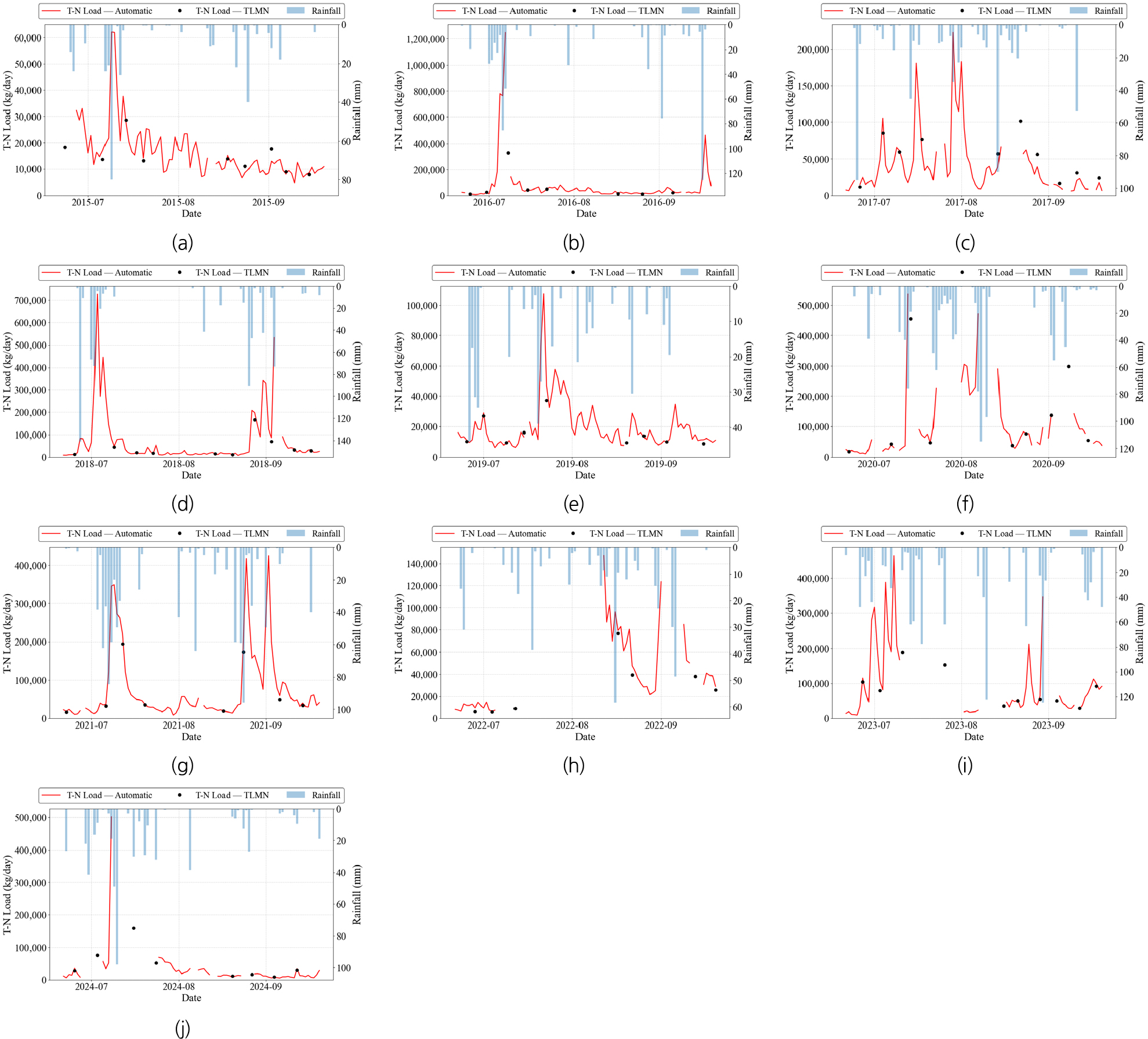
- This study assesses the applicability of high-frequency pollutant load estimation by integrating Korea’s Automatic Water-Quality Monitoring Network, Automatic Discharge Monitoring Network, and the low-frequency Total Load Monitoring Network. Two sections of the Nakdong River mainstream (Site 1: upstream of Chilgok Weir; Site 2: upstream of Gangjeong–Goryeong Weir) were analyzed using water-quality and discharge data collected from 2015 to 2024. High-frequency measurements from the automatic networks were compared with 8-day sampling data to evaluate temporal variations and correlations of total nitrogen (T-N) and total phosphorus (T-P) loads. T-N loads showed strong agreement between the monitoring systems, with coefficients of determination (R2) above 0.920. During rainfall events, the automatic monitoring network effectively captured short-term peak loads, compensating for the limitations of low-frequency sampling. In contrast, T-P exhibited weaker correlations and occasional discrepancies during storm events. These findings indicate that high-frequency automatic monitoring can improve pollutant load estimation by addressing the temporal gaps inherent in the Total Load Monitoring Network. Overall, the study demonstrates the practical value of sensor-based high-frequency data for pollutant load assessment and highlights the need for future integrated monitoring strategies and policy improvements in river water-quality management.
- COLLAPSE
본 연구는 국내에서 운영 중인 자동수질측정망과 자동유량측정망, 총량측정망을 연계하여 고빈도 오염부하량 산정의 적용 가능성을 평가하였다. 연구 대상은 낙동강 본류 내 두 구간(Site1: 칠곡보 상류, Site2: 강정고령보 상류)으로 설정하였으며, 2015년부터 2024년까지의 수질·유량 자료를 수집하여 분석하였다. 자동측정망의 고빈도 자료와 총량측정망(8일 간격)의 저빈도 자료를 비교하여 총질소(T-N)와 총인(T-P) 부하량의 시계열 변동 및 상관성을 평가하였다. 분석 결과, T-N 부하량의 경우 자동측정망과 총량측정망 간의 결정계수(R2)가 0.920 이상으로 높게 나타나 높은 일관성을 보였으며, 강우사상 시 자동측정망은 단기 피크 부하량을 정밀하게 포착하여 총량측정망의 저빈도 관측 한계를 효과적으로 보완하였다. 반면, T-P 부하량은 상관성이 낮고 일부 강우사상에서 두 관측망의 편차가 발생하였다. 이러한 결과는 자동측정망을 활용한 고빈도 측정이 총량측정망의 한계를 보완할 수 있음을 시사하며, 부하량 산정의 정밀도를 향상시킬 수 있음을 확인하였다. 본 연구는 국내 수질 및 유량 측정망을 연계 분석하여 센서 기반 고빈도 부하량 산정 방법론의 적용 가능성을 실증하였으며, 향후 통합측정망 운영의 필요성을 검증하고, 정책적 개선 방향을 제시했다는 점에서 의의가 있다.
-
Applicability of pollutant loading estimation approach based on high-frequency monitoring networks
-
Research Article
-
Enhancing virtual sensors for riverine Total Nitrogen (T-N) and Total Phosphorus (T-P) using land-use characteristics
토지 이용 특성을 고려한 하천의 T-N, T-P 가상 센서 개선 방안 연구
-
Yumin Kang, Su Han Nam, Sangung Lee, Tae Young Kim, Jong Hyun Lee, Min Ju Kim, Young Do Kim
강유민, 남수한, 이상웅, 김태영, 이종현, 김민주, 김영도
- Recent studies have highlighted that river water quality is strongly influenced by the spatial heterogeneity of land-use characteristics such as urbanization, agricultural …
최근 하천 수질은 기후 변화와 더불어 도시화·농업화·산림 구조 등 토지이용 특성의 공간적 이질성에 따라 크게 달라지며, 동일한 수질 구성 인자라도 유역의 토지피복 …
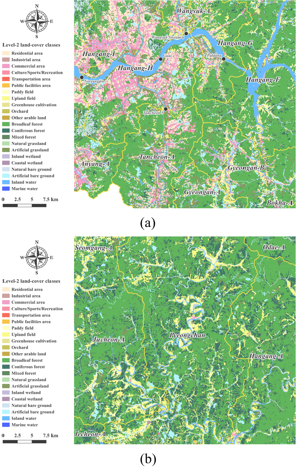
- Recent studies have highlighted that river water quality is strongly influenced by the spatial heterogeneity of land-use characteristics such as urbanization, agricultural intensity, and forest structure. However, most virtual-sensor-based water-quality prediction approaches still rely on uniform modeling frameworks that do not fully account for these land-use-driven differences in pollutant behavior. To address this gap, this study developed cluster-based virtual sensor models for estimating Total Nitrogen (T-N) and Total Phosphorus (T-P) concentrations across 37 watershed-outlet monitoring sites in the Han River Basin. We utilized water-quality variables including WT, DO, pH, EC, Chl-a, SS, NO3-N, NH3-N, and PO4-P and constructed prediction models using Multiple Linear Regression (MLR), Random Forest (RF), and Extreme Gradient Boosting (XGB). Spatial clustering was integrated to enhance model precision and interpretability by capturing land-use-based differences among sub-watersheds. Model evaluation showed that T-N predictions exhibited relatively consistent performance across algorithms, whereas T-P predictions demonstrated substantial variability among clusters and models, highlighting the strong nonlinearity and spatial heterogeneity associated with phosphorus dynamics. SHAP analysis revealed that NO3-N and NH3-N were the dominant predictors for T-N, while SS and PO4-P played leading roles in T-P estimation. Cluster-specific differences in predictor sensitivity and directional influence were also observed, particularly for SS and PO4-P, which exhibited sign reversals depending on land-use context and model type. These findings underscore the importance of incorporating land-use characteristics into machine-learning-based water-quality prediction and demonstrate the potential of cluster-informed virtual sensors to support more targeted and adaptive water-quality management strategies.
- COLLAPSE
최근 하천 수질은 기후 변화와 더불어 도시화·농업화·산림 구조 등 토지이용 특성의 공간적 이질성에 따라 크게 달라지며, 동일한 수질 구성 인자라도 유역의 토지피복 배경에 따라 서로 다른 반응과 민감도를 보인다. 그럼에도 기존의 가상 센서 기반 수질 예측 연구는 이러한 토지이용도 기반 공간적 차이를 충분히 반영하지 못한 한계가 존재한다. 본 연구는 한강권역 37개 단위유역 말단 지점을 대상으로, WT, DO, pH, EC, Chl-a, SS, NO3-N, NH3-N, PO4-P 등의 수질 자료를 활용해 가상 센서 기반 T-N 및 T-P 농도 산정 모델을 구축하였다. 다중선형회귀(MLR), 랜덤 포레스트(RF), 그래디언트 부스팅(XGB)을 적용하고, 공간적 clustering 기법을 도입해 모델의 정밀도와 해석 가능성을 향상시켰다. 평가 결과, T-N 산정에서는 모델 간 성능 차이가 크지 않았으나, T-P 산정에서는 cluster와 모델 간 성능 편차가 두드러져 P 계열 항목의 지역 이질성과 비선형성이 중요한 영향을 미침을 확인했다. SHAP 분석 결과, T-N은 NO3-N, NH3-N이, T-P는 SS, PO4-P가 주요 기여 변수로 나타났으며, cluster별 민감도와 영향 방향성의 차이도 확인되었다. 특히 SS와 PO4-P는 모델 간 부호 차이를 보였다. 본 연구는 머신러닝 기반 수질 산정의 해석 가능성과 지역 맞춤형 수질 관리 전략의 기초자료 제공 가능성을 제시한다.
-
Enhancing virtual sensors for riverine Total Nitrogen (T-N) and Total Phosphorus (T-P) using land-use characteristics
-
Research Article
-
Experimental evaluation of the applicability of LISST-200X for high-turbidity measurements
실험기반 LISST-200X 활용 고탁수 측정 적용성 평가 연구
-
Ok, GwangminㆍKim, JongminㆍChoi, Bo GyeongㆍKim, Young Do
옥광민, 김종민, 최보경, 김영도
- Recent extreme rainfall and typhoon events driven by climate change have caused severe high-turbidity problems in reservoirs and rivers, posing significant challenges …
최근 기후변화로 인한 집중호우와 태풍으로 발생하는 고탁수 문제는 저수지와 하천의 수질관리에 심각한 문제를 발생시킨다. 기존의 부유사 농도 측정은 채수와 실험실 분석에 의존하여 …
- Recent extreme rainfall and typhoon events driven by climate change have caused severe high-turbidity problems in reservoirs and rivers, posing significant challenges for water quality management. Conventional methods for measuring suspended sediment concentration (SSC) rely on manual sampling and laboratory analysis, which are time-consuming and unsuitable for real-time monitoring. Furthermore, the accuracy of turbidity–SSC relationships is often compromised by variations in particle size distribution, while high-turbidity conditions induce multiple scattering within the optical path, leading to overestimation of both concentration and particle size. To address these limitations, this study evaluated the applicability of the LISST-200X equipped with a Path Reduction Module (PRM) for SSC measurements under high-turbidity conditions. Experiments were conducted in an indoor recirculating flume using four particle-size fraction scenarios derived from sediment distributions observed in the upstream region of the Soyang River Basin. SSC was sequentially measured using both the standard LISST-200X and the PRM-mounted LISST-200X, while turbidity was simultaneously monitored with a YSI-EXO2 sensor. The acquired datasets were stratified by particle-size fraction, and variability was reduced by applying temporal averaging and a median filter technique. The results showed that the measurement range expanded from approximately 250 FNU with the standard LISST-200X to 300 FNU with the PRM, confirming the feasibility of stable monitoring even under high-turbidity conditions. Incorporating particle-size stratification significantly improved the linearity of turbidity–SSC relationships, with the median filter effectively removing outliers and reducing variability. This study provides experimental evidence that the LISST-200X with PRM can serve as a practical tool for SSC monitoring in high-turbidity environments, while also demonstrating that integrating particle-size variability and correction techniques enhances the accuracy and reliability of turbidity-based SSC estimation models.
- COLLAPSE
최근 기후변화로 인한 집중호우와 태풍으로 발생하는 고탁수 문제는 저수지와 하천의 수질관리에 심각한 문제를 발생시킨다. 기존의 부유사 농도 측정은 채수와 실험실 분석에 의존하여 실시간 모니터링에 한계가 있으며, 탁도-부유사 관계식 또한 입자 크기 분율에 따른 정확도 저하 문제가 제기되어 왔다. 또한 고탁도 조건에서는 광학 경로에서 다중 산란이 발생하여 농도와 입도를 과대 추정하는 한계가 있다. 이를 개선 하기 위해, 본 연구는 광 경로를 줄여주는 보조 모듈(Path Reduction Module, PRM)을 활용하여 고탁수 조건에서의 부유사 농도 측정 가능성을 검토하였다. 실험은 소양강 상류에서 조사된 입도 분포를 반영하여 네 가지 분율 조건을 설정하고 실내 순환수로에서 진행하였다. 동일 조건에서 기본 LISST-200X와 PRM 장착 LISST-200X를 순차적으로 측정하였다. YSI-EXO2를 병행하여 탁도를 측정하였으며, 취득된 데이터는 분율별로 세분화한 후 시간 평균화 및 median filter 기법을 적용하여 부유수 농도의 변동성을 보정하였다. 그 결과, PRM 모듈 적용 시 측정 가능 범위가 약 250 FNU에서 300 FNU로 증가되어 고탁수 환경에서도 안정적인 모니터링이 가능함을 확인하였다. 또한 입자 크기 분율을 반영할 경우 탁도-부유사 관계의 선형성이 크게 향상되었으며, median filter는 이상치 제거와 변동성 저감에 효과적이었다. 본 연구는 LISST-200X와 PRM을 활용한 실험적 검증을 통해, 탁도 기반 부유사 농도 추정 모델의 정교화와 고탁수 환경 모니터링의 실용적 개선 가능성을 제시하였다.

-
Experimental evaluation of the applicability of LISST-200X for high-turbidity measurements
-
Research Article
-
Development and implementation strategies for smart web-based data platform for integrated management of water quality and flow
지능형 수질·유량 통합관리 시스템 개발 및 활용방안 연구
-
Oh, Jungsun
오정선
- This study developed a Smart Web-based Data Platform for Integrated Management of Water Quality and Flow, which enables comprehensive management and analysis …
본 연구에서는 센서가 장착된 무인원격이동체(unmanned remote system)를 기반으로 측정된 수질 및 유량 데이터를 통합적으로 관리·분석할 수 있는 지능형 수질·유량 통합관리 시스템(Smart Integrated …
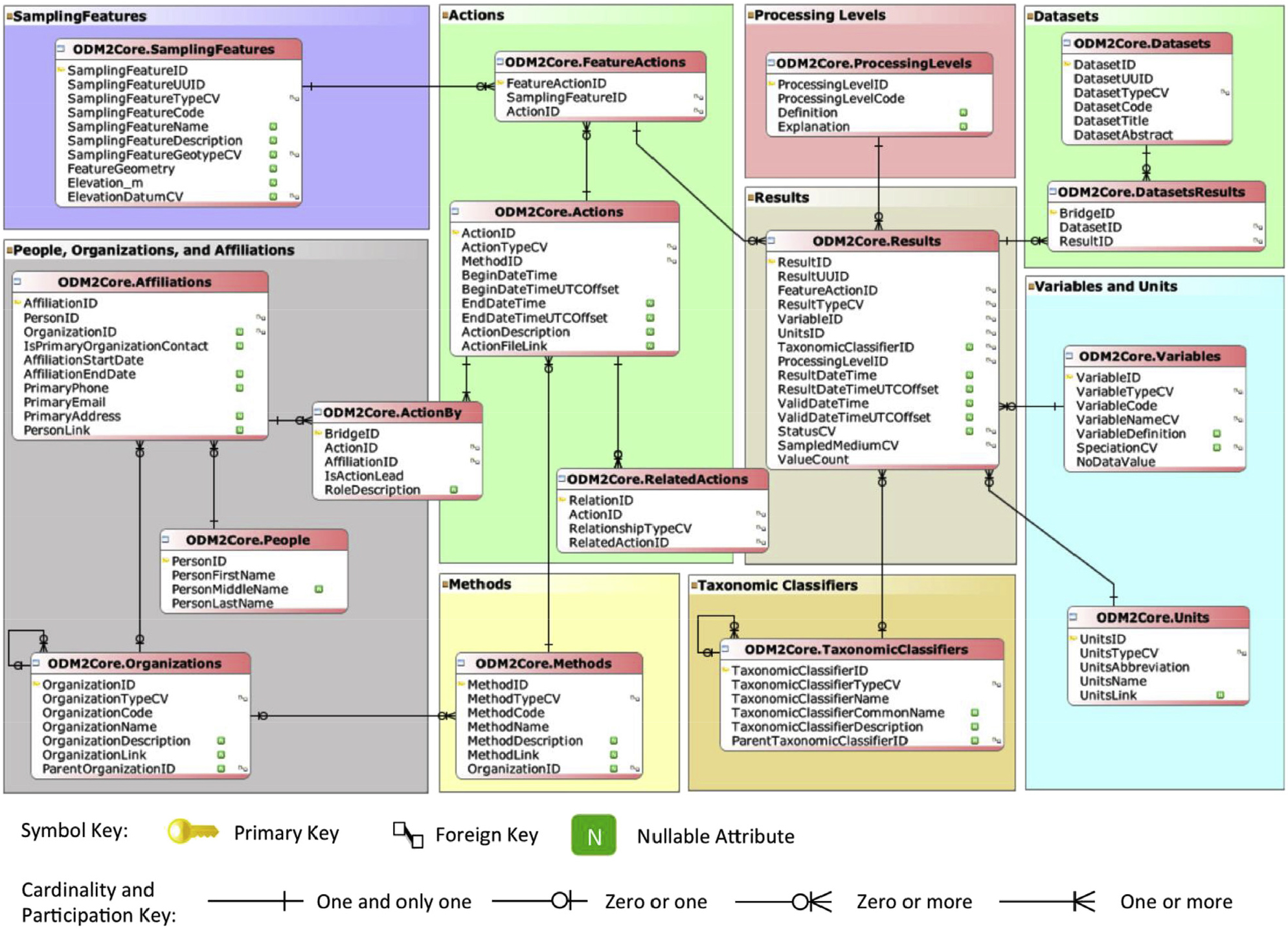
- This study developed a Smart Web-based Data Platform for Integrated Management of Water Quality and Flow, which enables comprehensive management and analysis of water quality and flow data measured by sensor-equipped unmanned remote systems. The system applies standardized data structures based on ODM2, WaterML 2.0, and RiverML 0.2, automating data collection, preprocessing, quality control, and three-dimensional (3D) visualization. It also supports real-time integration with national platforms such as WAMIS (Water Resources Management Information System) and WEIS (Water Environment Information System). Field applications were conducted at four testbeds such as the Nakdong-Geumho-Jincheon River confluence (Samunjin Bridge area) and Paldang Lake. Analysis results demonstrated that the system could more accurately determine flow ratios at the confluence and quantify the spatial variations of water quality parameters in 3D. At Paldang Reservoir, chlorophyll-a and nutrient concentrations were assessed in 3D, providing baseline data for early detection of algal blooms and for predicting their occurrence and dynamics. Additionally, correlation and regression analyses between water quality parameters and flow data were used to identify influencing factors and establish regression models. This system provides a foundation for integrated management of 3D observational data and quantitative analysis of water quality-flow interactions, and is expected to contribute to the future development of intelligent response systems.
- COLLAPSE
본 연구에서는 센서가 장착된 무인원격이동체(unmanned remote system)를 기반으로 측정된 수질 및 유량 데이터를 통합적으로 관리·분석할 수 있는 지능형 수질·유량 통합관리 시스템(Smart Integrated Water Data Management System)을 구축하였다. 본 시스템은 ODM2, WaterML 2.0 및 RiverML 0.2 표준구조를 적용하여 데이터의 수집, 전처리, 품질검증, 3차원(3D) 시각화를 자동화하였으며, 국가 수자원관리시스템(WAMIS)과 물환경정보시스템(WEIS)과의 실시간 연계를 지원한다. 현장 적용은 낙동강·금호강·진천천 합류부(사문진교 인근)와 팔당호 등을 대상으로 수행하였다. 분석 결과, 낙동강 ·금호강 ·진천천 합류부에서는 유량비를 좀 더 정확하게 파악할 수 있었고 수질항목들의 공간적 변화를 3차원적으로 정량화하는 데에 효과적이었다. 팔당호에서는 클로로필-a 및 영양염 농도를 3차원적으로 파악함으로써 녹조의 조기탐지, 발생 양상 및 변화를 예측하는 데 기초자료로 활용 가능함을 확인하였다. 또한, 각 수질항목과 유량 데이터 간의 상관·회귀분석을 통해 영향요인을 규명하고 회귀식을 제시하는 데에 활용 가능하였다. 본 시스템은 3차원 관측데이터를 통합 관리하고 수질·유량 상호작용을 정량적으로 분석할 수 있는 기반을 제공하며, 향후 지능형 대응체계로의 전환에 기여할 것으로 기대된다.
-
Development and implementation strategies for smart web-based data platform for integrated management of water quality and flow
-
Research Article
-
A study on improving real-time data transmission reliability for water environment measurement USVs utilizing hybrid communication networks
다중통신망을 활용한 물환경 계측 자율무인선의 실시간 데이터 전송 신뢰성 향상 연구
-
Jun, ChanwoongㆍSong, YongsikㆍKim, MoogunㆍAhn, HyojinㆍLee, Hyunwoo
전찬웅, 송용식, 김무건, 안효진, 이현우
- This study developed and analyzed the performance of a hybrid communication system integrating LTE and Starlink to support the stable and efficient …
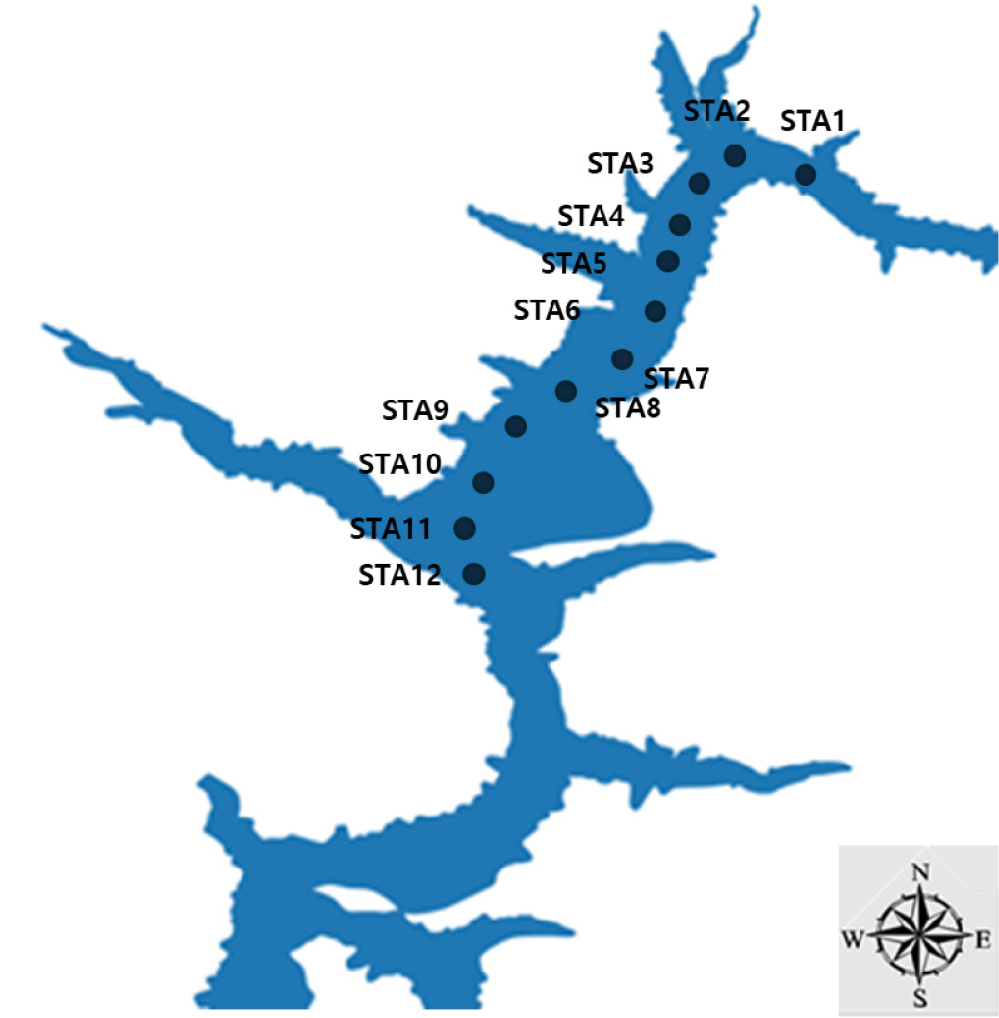
본 연구는 물환경 계측 자율무인선(USV)이 하천과 호소에서 시·공간적으로 변동하는 수리·수질 구조를 공백역 없이 안정적으로 계측하고 안전하고 효율적인 자율운항을 지원하기 위해 LTE와 Starlink를 …
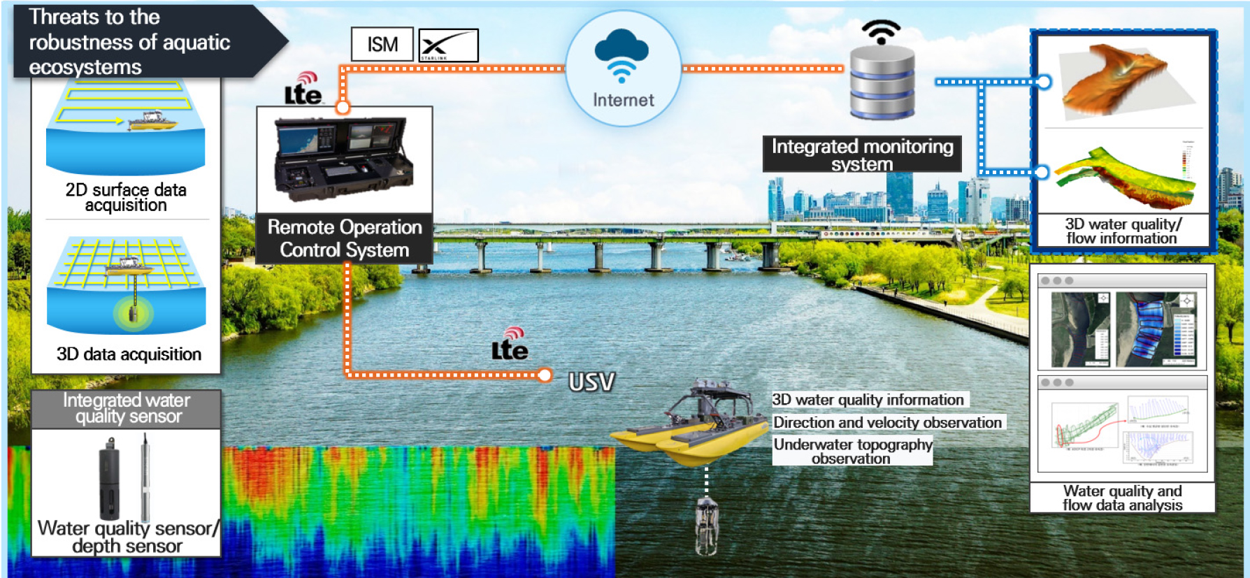
- This study developed and analyzed the performance of a hybrid communication system integrating LTE and Starlink to support the stable and efficient autonomous navigation of Unmanned Surface Vehicles (USVs) and to ensure the reliability of real-time transmission for water environment measurement data. The proposed system addresses communication issues caused by the limitations of existing infrastructure, such as LTE shadow zones in rivers and reservoirs. It guarantees communication continuity by utilizing high-speed, low-latency LTE as the primary network in standard environments and switching to broadband, low-latency Starlink satellite internet in shadow zones beyond service range. An intelligent network switching algorithm incorporating Policy-Based Routing (PBR) dynamically selects the optimal network by comprehensively evaluating the real-time communication environment, data importance, and quality requirements. Field simulations conducted at Lake Soyang demonstrated that the developed system offers superior performance compared to existing single networks, achieving integrated coverage of over 99.90 %, a data transmission rate exceeding 95.00 %, and a maximum latency of less t 150 ms. This study is expected to contribute to establishing a highly reliable hydraulic and water quality monitoring infrastructure by utilizing next-generation Low Earth Orbit (LEO) satellite systems like Starlink to minimize data loss due to instability and ensure the operational safety of USVs.
- COLLAPSE
본 연구는 물환경 계측 자율무인선(USV)이 하천과 호소에서 시·공간적으로 변동하는 수리·수질 구조를 공백역 없이 안정적으로 계측하고 안전하고 효율적인 자율운항을 지원하기 위해 LTE와 Starlink를 통합한 다중통신망 기반 계측 시스템을 개발하고 그 성능을 분석하였다. 하천과 호소 환경에서 LTE 음영지역 등 기존 통신 인프라의 한계로 발생하는 통신 문제를 개선하였다. 일반 환경에서는 고속·저지연 LTE를 주 통신망으로 사용하고, 서비스 범위를 벗어난 음영지역에서는 광대역·저지연 Starlink 위성 인터넷을 활용하여 통신 연속성을 보장하였다. 핵심 기술인 정책 기반 라우팅(PBR)이 적용된 지능형 네트워크 스위칭 알고리즘은 실시간 통신환경, 데이터 유형별 중요도 및 품질 조건 등을 종합적으로 판단하여 최적의 네트워크를 동적으로 선택하고 전환한다. 소양호 현장 시뮬레이션 결과, 개발된 시스템은 기존의 단일 통신망 대비 통합 커버리지(99.90 % 이상), 데이터 전송률(95.00 % 이상), 지연시간(최대지연 150 ms 이하) 측면에서 우수한 성능을 입증하였다. 이 연구는 Starlink와 같은 차세대 LEO 위성 시스템을 활용하여 통신 불안정으로 인한 데이터 누락을 최소화하고 물환경 계측 자율무인선의 운항 안전성을 확보하여 고신뢰 수리·수질 모니터링 인프라 구축에 기여할 것으로 기대된다.
-
A study on improving real-time data transmission reliability for water environment measurement USVs utilizing hybrid communication networks
Journal Informaiton
 Journal of Korea Water Resources Association
Journal Informaiton
Journal Informaiton - close
 Journal of Korea Water Resources Association


