
-
Research Article
-
Development of a hybrid water-energy-food nexus system for Chungcheongnam-do using a combined long short-term memory and multi-output regression model
장단기 메모리와 다중 출력 회귀 결합 모형 기반의 충청남도 복합 물-에너지-식량 넥서스 시스템 개발
-
Ji Eun Kim, Min Ji Kim, Tae-Woong Kim
김지은, 김민지, 김태웅
- As climate change and rapid industrialization exacerbate resource scarcity, the importance of an integrated management approach that links and manages water, energy, …
기후변화와 산업 발전으로 인해 자원 고갈 위기가 커지면서, 물, 에너지, 식량 자원을 연계하여 통합적으로 관리하는 것이 중요해지고 있다. 기존의 개별 관리 방식으로는 …
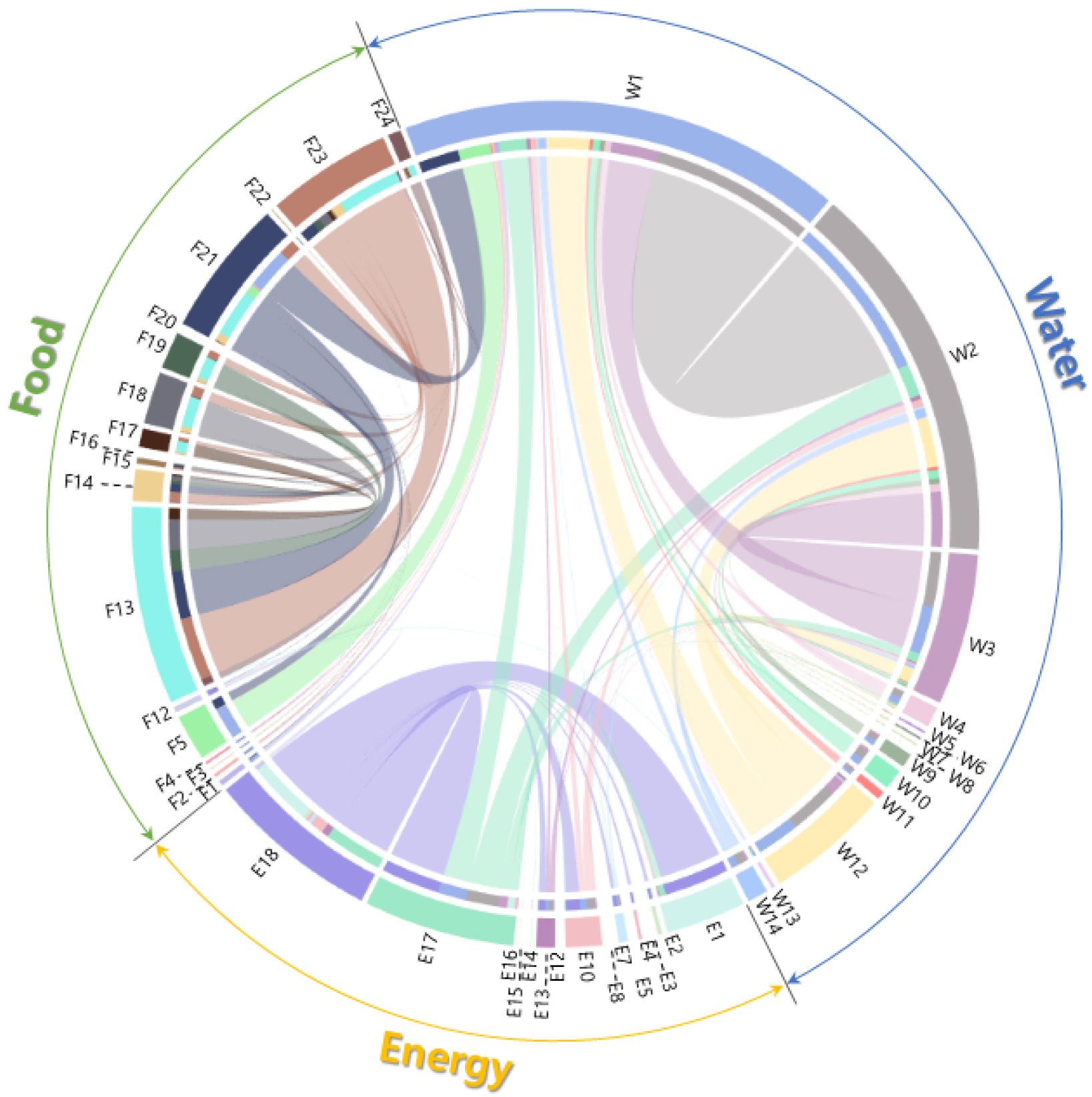
- As climate change and rapid industrialization exacerbate resource scarcity, the importance of an integrated management approach that links and manages water, energy, and food resources has become increasingly critical. The existing fragmented management methods are ill-equipped to address the intricate interactions between resources, making it challenging to respond effectively to complex crises. To quantitatively assess resource interactions in the Chungcheongnam-do, this study developed a hybrid water-energy-food (WEF) nexus system that combines long short-term memory (LSTM) and multi- output regression (MOR). The system employed various input and output factors spanning 2014 to 2022, including precipitation, reservoir storage, water supply and usage, energy generation and consumption, and agricultural and livestock production and consumption, along with stress indices calculated from sectoral supply and production. The results indicated that the water and food sectors exhibited the most dominant interaction within the Chungcheongnam-do WEF nexus system. Furthermore, it was found that precipitation significantly influenced not only crop production, but also energy generation. Especially, the water stress index accounted for over 45% of the total nexus stress, identifying it as the critical determinant of system vulnerability in the region. The simulation of historical resource supply and demand fluctuations by sector using LSTM verified the model’s reproducibility, yielding Ra2 values ranging from 0.49 to 0.78 and KGE values ranging from 0.47 to 0.89. In contrast, the hybrid nexus system combining LSTM-MOR yielded higher Ra2 and KGE than the standalone LSTM model. Consequently, the LSTM-MOR hybrid model developed in this study enables comprehensive nexus evaluations through sensitivity analysis for climate change scenarios, making it an essential asset for informed resource management and policy-making.
- COLLAPSE
기후변화와 산업 발전으로 인해 자원 고갈 위기가 커지면서, 물, 에너지, 식량 자원을 연계하여 통합적으로 관리하는 것이 중요해지고 있다. 기존의 개별 관리 방식으로는 복잡한 상호작용을 반영하지 못해, 복합적인 자원 위기에 효과적으로 대응하기 어렵다. 본 연구에서는 충청남도 지역을 대상으로 자원 간의 상호작용을 정량적으로 평가하기 위하여, 장단기 메모리(LSTM)와 다중 출력 회귀(MOR) 모형을 결합한 복합 물-에너지-식량(WEF) 넥서스 시스템을 구축하였다. 2014년∼2022년 기간의 강수량, 저수량, 용수 생산량 및 이용량, 에너지 발전 소비량, 농축산 생산·소비량과 부문별 공급 및 생산량으로부터 산정된 스트레스 지수를 시스템의 입력 및 출력 인자로 활용하였다. 그 결과, 충청남도 WEF 넥서스 시스템에서는 물과 식량 부문이 가장 지배적인 상호작용을 보였으며, 강수량은 식량작물 생산뿐만 아니라 에너지 생산에도 크게 영향을 미치는 것으로 나타났다. 특히, 물 스트레스가 전체의 45% 이상을 차지하며, 충청남도의 시스템 취약성을 결정하는 핵심 인자로 확인되었다. LSTM을 활용하여 과거 기간의 부문별 자원의 수요량 및 공급량 변동성을 모의하고 모형의 재현성을 검증한 결과, Ra2는 0.49∼0.78, KGE는 0.47∼0.89의 범위로 나타났다. 반면, LSTM과 MOR 모형이 결합된 복합 넥서스 시스템의 Ra2와 KGE는 LSTM만 적용한 결과에 비해 높게 나타났다. 따라서 본 연구에서 개발한 LSTM-MOR 기반의 WEF 넥서스 시스템은 기후변화 시나리오별 민감도 분석을 통해 지역 단위의 넥서스 평가를 가능케 하며, 향후 자원 관리 및 정책 결정을 지원하는 핵심적인 도구로 활용될 수 있을 것이다.
-
Development of a hybrid water-energy-food nexus system for Chungcheongnam-do using a combined long short-term memory and multi-output regression model
-
Research Article
-
Conditional probability and return period of extreme summer heatwave events under preceding drought events
선행 가뭄 영향에 의한 여름철 극한 고온의 조건부 확률 및 재현기간 분석
-
Jeongwon Lee, Chaelim Lee, Sangdan Kim
이정원, 이채림, 김상단
- The study quantitatively assessed the influence of preceding drought conditions on the occurrence risk of extreme summer heat at five representative ASOS …
본 연구는 한국의 대표적인 5개 ASOS 관측 지점을 대상으로 선행 가뭄 조건이 여름철 극한 고온 발생 위험에 미치는 영향을 Copula 기반 결합분포를 …
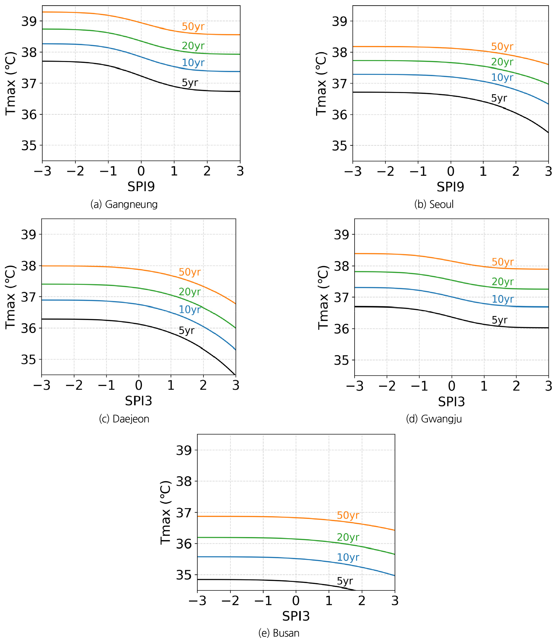
- The study quantitatively assessed the influence of preceding drought conditions on the occurrence risk of extreme summer heat at five representative ASOS observation sites in Korea using a copula-based joint distribution framework. Drought conditions were characterized using standardized precipitation indices (SPI) at multiple time scales, and the optimal SPI time scale for each site was identified based on Spearman’s rank correlation with daily maximum temperature (Tmax). Marginal distributions for SPI and Tmax were modeled independently, after which Clayton, Frank, and Gumbel copulas were evaluated to determine the most appropriate dependence structure at each site. The results consistently revealed a negative monotonic relationship between preceding SPI and Tmax across all sites. Under dry and extremely dry conditions (SPI < -0.5 and SPI < -1.3), the probability of exceeding extreme Tmax thresholds increased markedly relative to estimates derived from univariate distributions. In contrast, wet and extremely wet conditions (SPI > 0.5 and SPI > 1.3) were associated with a systematic reduction in extreme heat probabilities, indicating an asymmetric response to antecedent moisture conditions. Copula-based conditional return period analysis further demonstrated that extreme heat events of the same magnitude occurred at substantially shorter intervals under drought conditions than suggested by univariate frequency analysis, with risk amplification intensifying for more severe extremes. By moving beyond simple correlation or univariate approaches, this study provides a quantitative framework for assessing compound drought–heat risks using conditional probability and return period metrics, offering practical insights for early warning and climate risk management.
- COLLAPSE
본 연구는 한국의 대표적인 5개 ASOS 관측 지점을 대상으로 선행 가뭄 조건이 여름철 극한 고온 발생 위험에 미치는 영향을 Copula 기반 결합분포를 이용하여 정량적으로 평가하였다. 가뭄지수로는 다양한 time-scale의 SPI를 적용하고, 스피어만 상관계수 분석을 통해 지점별로 극한 고온(Tmax)과 가장 강한 연계를 보이는 최적 SPI time-scale을 선정하였다. 이후 SPI와 Tmax의 한계분포를 각각 모형화한 뒤, Clayton, Frank, Gumbel Copula를 비교하여 지점별 최적 결합구조를 도출하였다. 분석 결과, 모든 지점에서 1개월 선행 SPI와 Tmax 사이에는 음의 단조 관계가 확인되었으며, 건조 및 극심한 건조 조건(SPI < -0.5, SPI < -1.3) 하에서 Tmax의 극값 초과확률은 한계분포 기반 확률보다 유의하게 증가하였다. 반면, 습윤 및 극심한 습윤 조건(SPI > 0.5, SPI > 1.3)에서는 극한 고온 발생 확률이 일관되게 감소하는 비대칭적 반응이 나타났다. 특히 Copula 기반 조건부 재현기간 분석 결과, 선행 가뭄 조건에서는 동일한 수준의 극한 고온이 단변량 분석에서 추정된 재현기간보다 훨씬 짧은 주기로 발생함이 확인되었으며, 이러한 위험 증폭 효과는 극값 영역으로 갈수록 더욱 뚜렷해졌다. 본 연구는 단순 상관 분석이나 단변량 접근을 넘어, 조건부 확률과 재현기간 지표를 활용하여 복합 가뭄–고온 위험을 정량적으로 평가할 수 있는 분석 틀을 제시한다는 점에서 의의를 가진다.
-
Conditional probability and return period of extreme summer heatwave events under preceding drought events
-
Research Article
-
Market entry strategies of South Korea for the United Arab Emirates water sector
한국의 아랍에미리트 물 시장 진출 전략
-
Yookyung Lee, Seungho Lee
이유경, 이승호
- This study analyzes the current status and challenges of Korean companies' entry into the UAE water market and proposes strategic approaches for …
본 연구는 한국 기업의 아랍에미리트(United Arab Emirate, UAE) 물 시장 진출 현황과 과제를 분석하고 이를 토대로 전략적 진출 방안을 제시하는 것을 목적으로 …
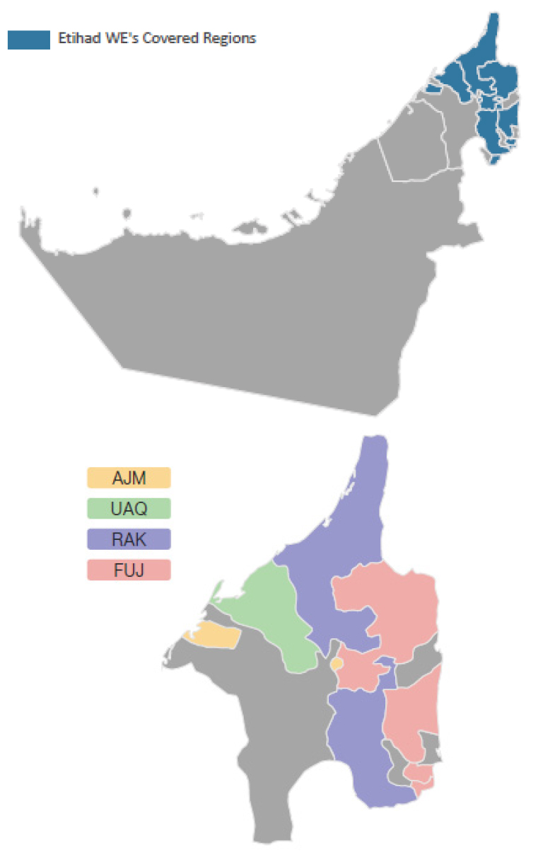
- This study analyzes the current status and challenges of Korean companies' entry into the UAE water market and proposes strategic approaches for market penetration. The research employed a mixed-method approach combining literature review and two field works conducted in December 2023 and May 2024, including semi-structured in-depth interviews with officials from key local institutions such as the Department of Energy Abu Dhabi (DoE), Dubai Electricity and Water Authority (DEWA), and Etihad Water and Electricity (Etihad WE). The literature review identified three core analytical issues – competitive advantages, institutional entry barriers, and strategic entry pathwats – which were subsequently examined through field interviews designed to validate and contextualize these findings. The findings indicate that Korean companies have primarily focused on seawater desalination, smart water management, and wastewater reuse, yet remain limited to a fragmented approach centered on large-scale EPC contracts. Using Porter's (1990) Diamond Model, the study identifies Korea's RO desalination technology, smart water management experience, and industrial clusters as key competitive advantages. Meanwhile, applying Kostova's (1999) institutional distance framework reveals compound entry barriers encompassing regulatory, cognitive, and normative dimensions. Based on these analyses, the study proposes two strategies: first, implementing NRW reduction pilot projects in the Northern Emirates through performance-based contracts integrating the WASCO model with the Knowledge Sharing Project (KSP), grounded in the Uppsala model and beachhead strategy; second, a four-stage cooperative strategy emphasizing role allocation among the government, large corporations, and SMEs. The findings offer theoretical and practical implications for Korean companies and policymakers targeting the UAE water market.
- COLLAPSE
본 연구는 한국 기업의 아랍에미리트(United Arab Emirate, UAE) 물 시장 진출 현황과 과제를 분석하고 이를 토대로 전략적 진출 방안을 제시하는 것을 목적으로 한다. 연구 방법으로는 문헌조사와 2023년 12월 및 2024년 5월 두 차례에 걸친 현지 조사를 활용하였다. 문헌조사를 통해 경쟁우위 원천, 제도적 진입 장벽, 전략적 진입 경로라는 세 가지 핵심 분석 이슈를 도출하였다. 이를 검증 및 보완하기 위해 반구조화된 심층 면담을 설계하여 아부다비 에너지부(Department of Energy Abu Dhabi, DoE), 두바이 수전력청(Dubai Electricity and Water Authority, DEWA), 에티하드 수전력청(Etihad Water and Electricity, Etihad WE) 등 현지 기관 관계자와의 심층 면담을 통해 UAE 물 시장의 실태를 파악하였다. 분석 결과, 한국 기업은 UAE 물 시장에서 해수담수화, 스마트 물관리, 하수 재이용 등의 분야를 중심으로 진출하고 있으나 대형 EPC 수주 중심의 단편적 접근에 머물러 있는 한계가 있다. Porter(1990)의 다이아몬드 모델 분석을 통해 한국의 RO 담수화 기술력, 스마트 물관리 운영 경험, 대기업 및 중소기업 산업 클러스터가 핵심 경쟁우위 원천임을 확인하였다. 반면 Kostova (1999)의 제도적 거리 개념을 적용한 결과, ICV 규정과 PPP 금융 조달 역량이라는 규제적 거리, 현지 관망 운영 지식 부재라는 인지적 거리, 현지 기업 중심 시장 구조라는 규범적 거리가 복합적 진입 장벽으로 작동하고 있음이 규명되었다. 이러한 분석을 바탕으로 본 연구는 두 가지 전략을 제안한다. 첫째, 웁살라 국제화 과정 모델과 비치헤드 전략에 근거하여 Etihad WE 관할 북부 에미리트 소도시를 대상으로 무수수량(Non Revenue Water, NRW) 저감 시범 사업을 수행하고, WASCO 방식과 정부 간 지식공유사업(Knowledge Sharing Project, KSP)을 연계한 성과 기반 계약 방식으로 진입하는 전략을 제시한다. 둘째, 정부, 대기업, 중소기업의 역할 분담과 유기적 협력을 중심으로 한 시장 탐색, 진출 준비, 시장 개척, 본격 진출의 4단계 협력 전략을 제안한다. 본 연구의 결과는 UAE 물 시장 진출을 모색하는 한국 기업 및 정책 입안자에게 이론적, 실무적 시사점을 제공한다.
-
Market entry strategies of South Korea for the United Arab Emirates water sector
-
Research Article
-
Quantifying drought propagation and migration pathways using gridded drought indices and spatiotemporal clustering
격자기반 가뭄지수와 시공간 군집분석을 활용한 가뭄 전파 및 이동경로 분석
-
Mun, Young-SikㆍNam, Won-HoㆍAshok Mishra
문영식, 남원호, Ashok Mishra
- Drought is not a static phenomenon confined to a specific location but a dynamic spatiotemporal process characterized by onset, expansion, migration, and …
가뭄은 특정 지역에 국한된 정적인 현상이 아니라, 시간의 흐름에 따라 발생, 확산, 이동, 소멸하는 시공간적 동적 과정이다. 본 연구에서는 격자 기반 가뭄지수와 …
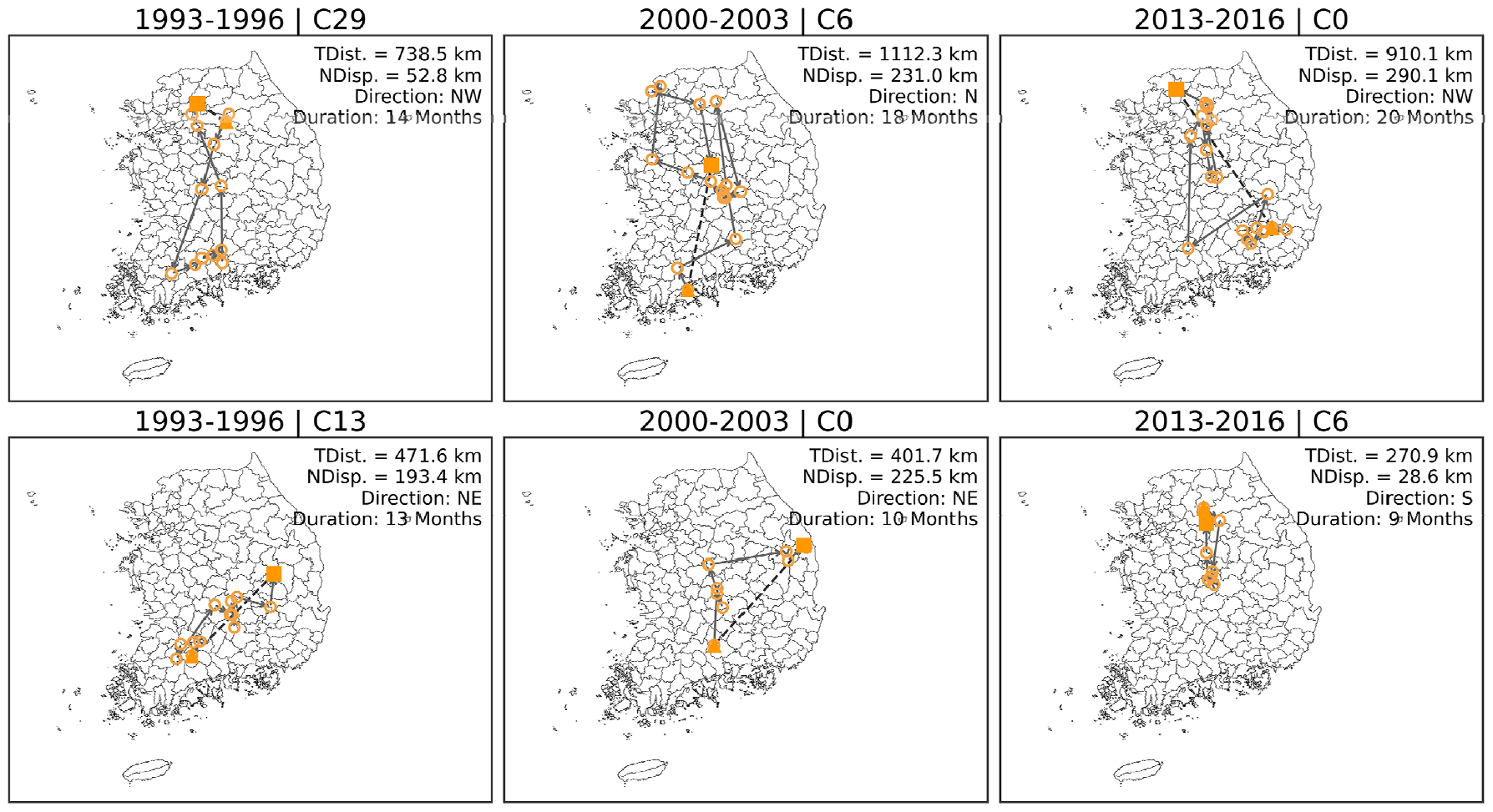
- Drought is not a static phenomenon confined to a specific location but a dynamic spatiotemporal process characterized by onset, expansion, migration, and decay. This study investigates the propagation and migration characteristics of drought events in South Korea using grid-based drought indices and the spatiotemporal clustering algorithm ST-DBSCAN. Monthly SPI-6 values were derived from satellite-based precipitation data (CHIRPS V3.0), and drought grids were identified to extract spatiotemporally connected drought clusters. Three large-scale drought events (1993-1996, 2000-2003, and 2013-2016) were selected to analyze the evolution of drought events across sequential stages, including onset, expansion, peak, and decay. The migration pathways and directional behavior of drought cluster centroids were quantified to reveal spatiotemporal dynamics. Results show that drought events consist of multiple interacting clusters that evolve sequentially and overlap in space and time, rather than forming a single contiguous structure. Across all representative events, northward migration was dominant, while additional movements toward the northeast, northwest, and south were also observed, indicating multidirectional propagation patterns. These findings demonstrate that drought migration exhibits both directional tendencies and complex spatial dynamics. By conceptualizing drought as a dynamic migrating system, this study provides a new perspective on drought propagation processes. The proposed approach has strong potential to enhance drought monitoring and early warning systems by incorporating migration dynamics and can be extended to the development of AI- and machine learning-based predictive models for drought evolution.
- COLLAPSE
가뭄은 특정 지역에 국한된 정적인 현상이 아니라, 시간의 흐름에 따라 발생, 확산, 이동, 소멸하는 시공간적 동적 과정이다. 본 연구에서는 격자 기반 가뭄지수와 시공간 군집분석 기법인 ST-DBSCAN을 활용하여 우리나라 가뭄의 전파 및 이동 특성을 정량적으로 분석하였다. 이를 위해 위성 기반 강수 자료(CHIRPS V3.0)를 이용하여 월 단위 SPI-6를 산정하고, 가뭄 격자를 추출한 후 시공간적으로 연결된 가뭄 군집을 식별하였다. 대규모 가뭄 기간(1993-1996, 2000-2003, 2013-2016)을 선정하여 가뭄의 발생, 확산, 피크, 소멸 단계별 진화를 분석하고, 군집 중심의 이동 경로 및 방향성을 정량적으로 평가하였다. 분석 결과, 가뭄은 단일 군집이 아닌 다수의 군집이 시간적으로 연속적으로 발생하고 상호 중첩되면서 하나의 가뭄 사건을 형성하는 동적 시스템으로 나타났다. 또한 대규모 가뭄 사건에서 북향 이동이 지배적으로 나타났으며, 일부 군집에서는 북동, 북서 및 남향 이동이 함께 나타나는 다방향성이 확인되었다. 이러한 결과는 가뭄 이동이 특정 방향성을 가지면서도 복합적인 시공간 전파 특성을 보인다는 것을 시사한다. 본 연구는 가뭄을 정적인 현상이 아닌 이동하는 동적 시스템으로 해석함으로써 가뭄 전파 메커니즘에 대한 이해를 확장하였다. 또한 제안된 접근법은 가뭄 이동 특성을 반영한 모니터링 및 조기경보 체계 구축에 활용될 수 있으며, 향후 인공지능 및 머신러닝 기반 가뭄 이동 경로 예측 모델 개발로 확장될 수 있다.
-
Quantifying drought propagation and migration pathways using gridded drought indices and spatiotemporal clustering
-
Research Article / 우수학생논문상
-
Automated multi-site parameter calibration and validation of WRF-Hydro in the Nakdong River basin using PEST
WRF-Hydro와 PEST를 활용한 낙동강 유역 다지점 매개변수 자동 보정 및 검증
-
Jiwon Choi, Bomi Kim, Yaewon Lee, Seong Jin Noh
최지원, 김보미, 이예원, 노성진
- This study established a multi-site automated calibration system by coupling the distributed hydrological model WRF-Hydro with the parameter optimization tool Model-Independent Parameter …
본 연구에서는 분포형 수문모형 WRF-Hydro와 자동 매개변수 최적화 도구 Model-Independent Parameter ESTimation (PEST)를 연계하여 다지점 관측 기반 자동 보정 체계를 구축하고, 낙동강 …
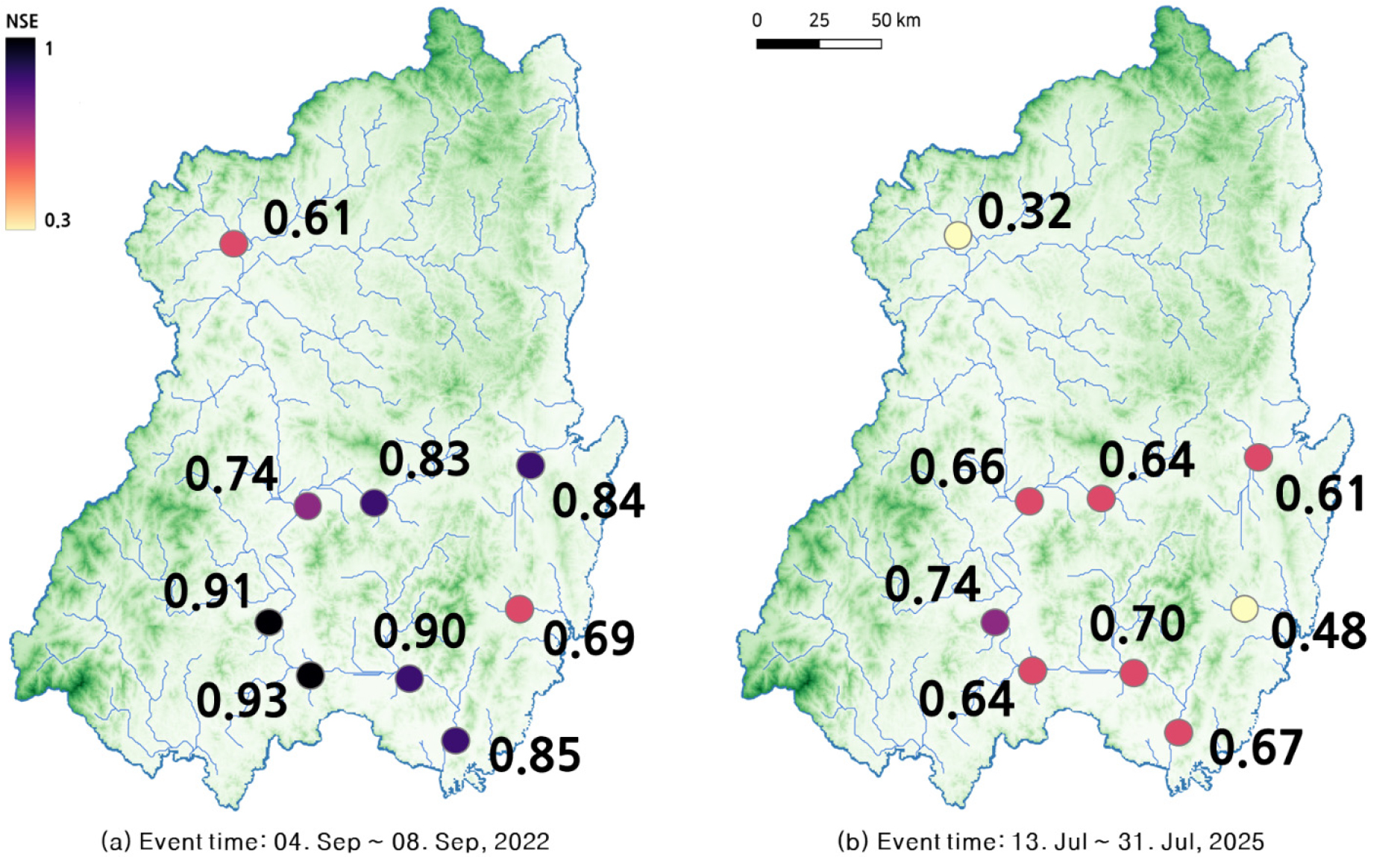
- This study established a multi-site automated calibration system by coupling the distributed hydrological model WRF-Hydro with the parameter optimization tool Model-Independent Parameter ESTimation (PEST), and evaluated the applicability across the Nakdong River basin (including Eastern sub-basins). WRF-Hydro was configured at a 500 m spatial resolution, and calibration and validation were performed for major flood events in 2022 and 2025. For the 2022 Typhoon Hinnamnor event, eight parameter combination scenarios involving REFKDT, DKSAT, and SMCMAX were evaluated to identify the optimal set for reproducing multi-site discharge. Prior to automated calibration, key river routing parameters for the Muskingum-Cunge module were determined based on a sensitivity analysis categorized by stream order to ensure physical consistency. The results demonstrated high performance, with NSE values of 0.8 or higher at nine comparison locations, including the Haman (Gyenae-ri) station, for the 2022 calibration event. Validation against the July 2025 heavy rain showed that the calibrated parameter set reproduced streamflow with an average NSE above 0.6 at major analysis locations under the tested meteorological conditions. However, performance limitations were observed at certain stations. Specifically, Ulsan (Sayeon) showed lower accuracy due to the heavy influence of hydraulic structures, while Mungyeong (Gimyong-ri) exhibited constraints related to spatial calibration. This study demonstrates the feasibility of applying an automated multi-site calibration system that integrates physics-based routing with PEST optimization for large-scale basins. This approach is expected to enhance runoff prediction accuracy and support decision-making for future water resource management and flood response.
- COLLAPSE
본 연구에서는 분포형 수문모형 WRF-Hydro와 자동 매개변수 최적화 도구 Model-Independent Parameter ESTimation (PEST)를 연계하여 다지점 관측 기반 자동 보정 체계를 구축하고, 낙동강 유역(동해안 인접 권역 포함)에서 적용성을 평가하였다. 연구 지역에 WRF-Hydro를 500 m 공간 해상도로 구축한 뒤, 2022년과 2025년 홍수 사상을 대상으로 보정 및 검증을 수행하였다. 2022년 태풍 힌남노 사상에 대해 REFKDT, DKSAT, SMCMAX 등 다양한 매개변수 조합 시나리오를 구성하고, 다지점 유량을 효과적으로 재현할 수 있는 최적 매개변수 조합을 선정하였다. 또한 보정에 앞서 하천 매개변수 민감도 분석을 통해 하천추적 모듈(Muskingum-Cunge)의 하천 차수별 주요 매개변수를 설정하였다. 적용 결과, 함안(계내리) 등 보정 지점을 포함한 비교대상 9개 지점에서 NSE 0.8 이상의 성능(2022 보정 사상 기준)을 확보하여 다지점 최적화 효과를 확인하였다. 2025년 7월 집중호우 사상에 대해 검증한 결과, 주요 분석 지점에서 NSE 평균 0.6 이상의 성능을 나타내어 검증 사상 조건에서 매개변수 조합의 적용 가능성을 확인하였다. 다만, 수리 구조물의 영향이 지배적인 울산(사연교)과 공간적 보정 한계를 보인 문경(김용리) 등 일부 지점에서는 재현성이 저하되었다. 본 연구를 통해 물리 기반 하천추적과 PEST 기반 자동 매개변수 최적화를 결합한 다지점 보정 체계의 대규모 유역 적용 가능성을 제시하였으며, 향후 수자원 관리 및 홍수 대응을 위한 유출 예측 고도화와 의사결정 지원에 활용될 수 있을 것으로 기대된다.
-
Automated multi-site parameter calibration and validation of WRF-Hydro in the Nakdong River basin using PEST
-
Research Article
-
Carbon emission reduction contribution analysis of hydropower and pumped-storage hydroelectricity
재생에너지 변동성 대응을 위한 수력 및 양수발전의 탄소배출량 저감 기여분석
-
Kyungmin Sung
성경민
- This study quantitatively evaluates the contribution of hydropower and pumped-storage hydropower (PSH) to the decarbonization of the power generation sector in support …
본 연구는 한국의 탄소중립 목표 달성을 위한 전력생산 부문의 탈탄소 전략 수립 과정에서 수력 및 양수발전의 기여 효과를 정량적으로 분석하였다. 2024년 기준 …
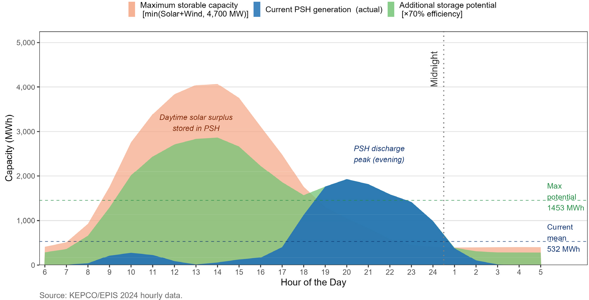
- This study quantitatively evaluates the contribution of hydropower and pumped-storage hydropower (PSH) to the decarbonization of the power generation sector in support of South Korea’s carbon neutrality goals. As of 2024, total amount of greenhouse gas emissions in Korea is 691.58 MtCO2-eq, of which the power generation sector accounts for approximately 241.6 MtCO2-eq (about 35%). Liquefied natural gas (LNG) and coal-fired power plants together contribute approximately 97% of emissions within the power sector. Under these conditions, PSH can reduce carbon emissions by storing surplus renewable electricity and discharging it during peak demand periods, thereby substituting high-carbon thermal generation. The analysis indicates that PSH currently achieves an annual reduction of approximately 3.37 MtCO-eq. When surplus electricity stored by PSH is assumed to be fully supplied by renewable energy sources, the potential reduction increases to approximately 17.12 MtCO-eq, equivalent to about 7% of total power sector emissions. Furthermore, the results suggest optimized time-based operational improvements could enhance effective generation capacity by nearly threefold (from 532 MWh to 1,947 MWh) even under existing installed capacity, indicating substantial untapped potential within the current system. Our findings highlight the significant role of pumped-storage hydropower as a strategic low-carbon infrastructure and demonstrate its future potential to support power sector decarbonization in South Korea.
- COLLAPSE
본 연구는 한국의 탄소중립 목표 달성을 위한 전력생산 부문의 탈탄소 전략 수립 과정에서 수력 및 양수발전의 기여 효과를 정량적으로 분석하였다. 2024년 기준 우리나라의 총 온실가스 배출량은 692백만 톤(CO2eq)이며, 이 중 전력 생산 부문이 약 242백만 톤으로 전체의 약 35%를 차지한다. 특히 LNG 및 유연탄 발전이 전력 부문 탄소 배출량의 약 97%를 차지하는 구조적 특성을 보이고있다. 이러한 발전 구조하에서 양수발전은 재생에너지의 잉여 전력을 저장하고 전력 수요가 집중되는 피크 시간대에 방전함으로써 고탄소 화력발전의 가동을 대체하는 역할을 수행한다. 분석 결과, 현재 운영 체계 기준으로 양수발전은 연간 약 3백만 톤의 탄소 저감 효과를 나타내는 것으로 산정되었다. 또한 양수발전의 충전 전력이 재생에너지로 공급된다고 가정할 경우, 총 17백 만 톤(전력부문 탄소배출량의 약 7%)의 감축이 가능한 것으로 분석되었다. 더불어 현행 설비 용량 하에서도 시간대별 최적 운영을 통한 효율 개선이 이루어질 경우, 실질적인 저장·발전 역량을 약 3배(532 MWh~1,947 MWh)까지 확대할 수 있는 잠재력이 존재하는 것으로 확인되었다. 본 연구 결과는 양수발전이 전력 부문 탄소저감에 실질적으로 기여하는 전략적인 기반시설임을 제시하며, 탄소중립 목표 달성과 기후변화 대응을 위한 미래 확장 가능성을 강조한다.
-
Carbon emission reduction contribution analysis of hydropower and pumped-storage hydroelectricity
-
Research Article
-
Assessing the contribution of spatial information in dam inflow prediction using spatio-temporal graph neural networks: A comparison of Chungju and Soyanggang dams
시공간 그래프 신경망을 활용한 댐 유입량 예측에서의 공간 정보 기여도 평가: 충주댐 및 소양강댐 비교
-
Taesik Kim, Tae-Woong Kim, Jiyoung Yoo, Hyung Suk Kim
김태식, 김태웅, 유지영, 김형석
- Accurate prediction of dam inflow is essential for flood control and water resources management. This study quantitatively evaluated the contribution of spatial …
댐 유입량의 정확한 예측은 홍수 제어 및 수자원 관리의 핵심 요소이다. 본 연구는 시공간 그래프 신경망(ST-GNN)을 활용한 댐 유입량 예측에서 공간 정보의 …
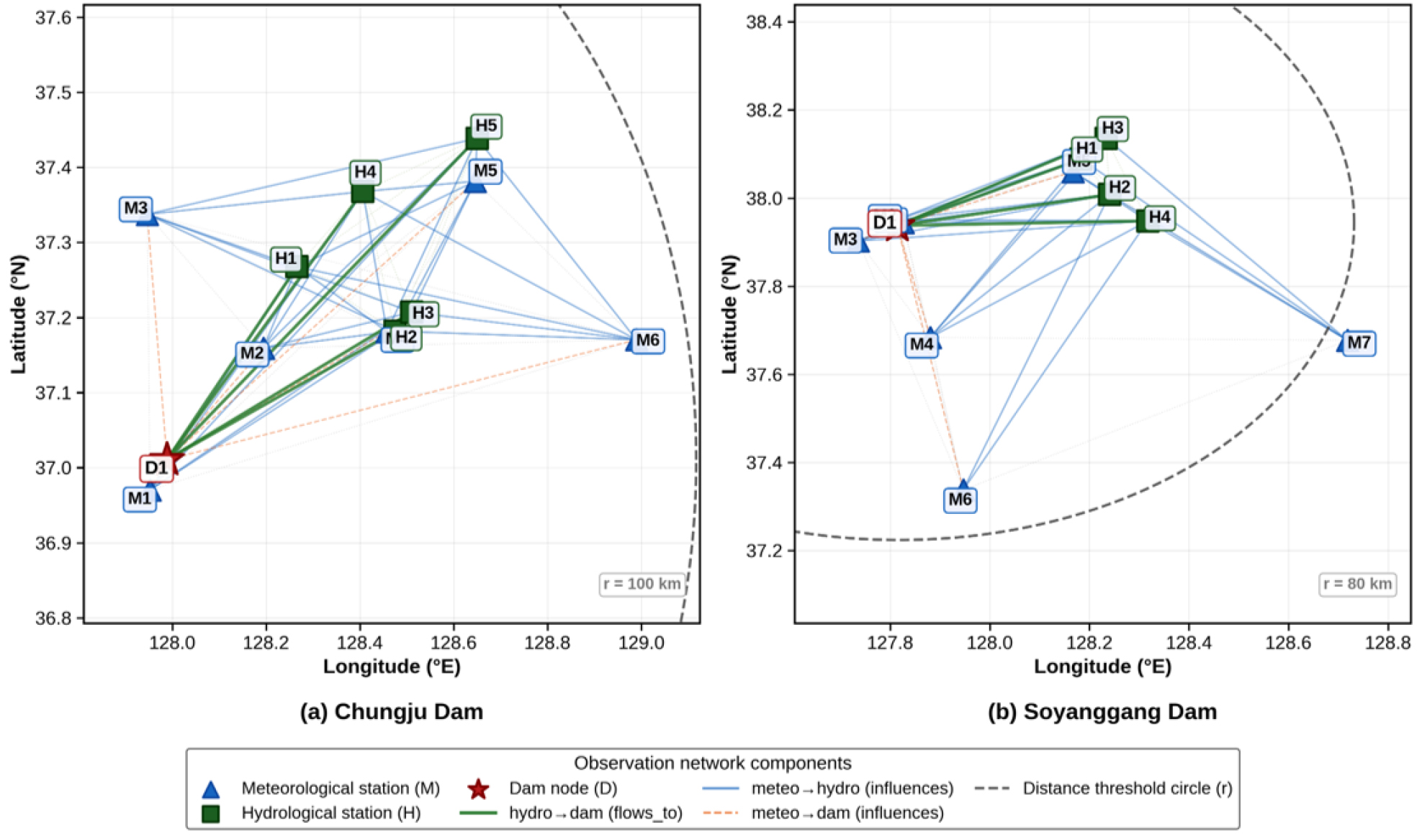
- Accurate prediction of dam inflow is essential for flood control and water resources management. This study quantitatively evaluated the contribution of spatial information in dam inflow prediction using Spatio-Temporal Graph Neural Networks (ST-GNN). ST-GNN and five baseline models (LSTM, GRU, TCN, Transformer, LSTM-Attention) were compared for Chungju Dam (6,648 km2) and Soyanggang Dam (2,703 km2) across five lead times (T+3h to T+48h). An ablation study quantified spatial information contribution by computing ΔNSE between ST-GNN with and without graph convolution layers. For Chungju Dam, ΔNSE turned positive from T+12h, reaching +0.028 at T+24h, with block bootstrap analysis confirming statistical significance (95% CI: [+0.010, +0.111]). In contrast, Soyanggang Dam showed negative ΔNSE across all lead times (T+24h: -0.035), indicating that graph-based spatial aggregation degraded performance in a steep, single-channel basin. These results demonstrate that the effectiveness of graph-based spatial information is basin-dependent, governed by stream network complexity and hydrological response characteristics, providing quantitative evidence for basin-specific model selection strategies.
- COLLAPSE
댐 유입량의 정확한 예측은 홍수 제어 및 수자원 관리의 핵심 요소이다. 본 연구는 시공간 그래프 신경망(ST-GNN)을 활용한 댐 유입량 예측에서 공간 정보의 기여도를 정량적으로 평가하였다. 충주댐(6,648 km2)과 소양강댐(2,703 km2)을 대상으로 ST-GNN과 5종 비교모형(LSTM, GRU, TCN, Transformer, LSTM-Attention)을 5개 선행시간(T+3h~T+48h)에 대해 비교하고, 소거실험을 통해 그래프 합성곱 계층 유무에 따른 ΔNSE를 산정하였다. 충주댐에서는 T+12h부터 ΔNSE가 양(+)으로 전환되어 T+24h에서 +0.028로 최대치를 기록하였으며, 블록 부트스트랩 분석 결과 95% 신뢰구간이 [+0.010, +0.111]로 통계적 유의성이 확인되었다. 반면 소양강댐에서는 전 선행시간에 걸쳐 음(-)의 ΔNSE가 산출되어(T+24h: -0.035), 급경사 단일 주하천 유역에서 그래프 기반 공간 집계가 예측 성능을 저하시키는 것으로 나타났다. 이러한 결과는 그래프 기반 공간 정보의 유효성이 하천망 구조 및 수문 응답 특성에 따라 유역별로 상이함을 실증하며, 댐 유입량 예측에서 유역 특성을 반영한 모형 선택 전략의 정량적 근거를 제시하였다. 다만, 두 유역에 한정된 결과로서 일반화를 위해서는 다양한 수문학적 특성을 가진 유역으로의 확장 연구가 필요하다.
-
Assessing the contribution of spatial information in dam inflow prediction using spatio-temporal graph neural networks: A comparison of Chungju and Soyanggang dams
-
Special Issue: 환경기초조사
-
Drone imagery and artificial intelligence-based investigation and management of pollution source distribution in the Miho River mid-watershed
드론 영상과 인공지능 분석을 활용한 미호강 중권역 오염원 분포 조사 및 관리 방안 연구
-
Inji Lee, Suho Bak, Miso Park, Seon-Woong Jang
이인지, 박수호, 박미소, 장선웅
- This study quantitatively analyzed the spatiotemporal distribution and management status of compost heaps in the Miho River mid-watershed using UAV imagery and …
본 연구는 미호강 중권역을 대상으로 드론 영상과 딥러닝 기반 인스턴스 세그멘테이션 기법을 적용하여 야적퇴비의 시공간적 분포 특성과 관리 상태를 정량적으로 분석하였다. 2023년 …
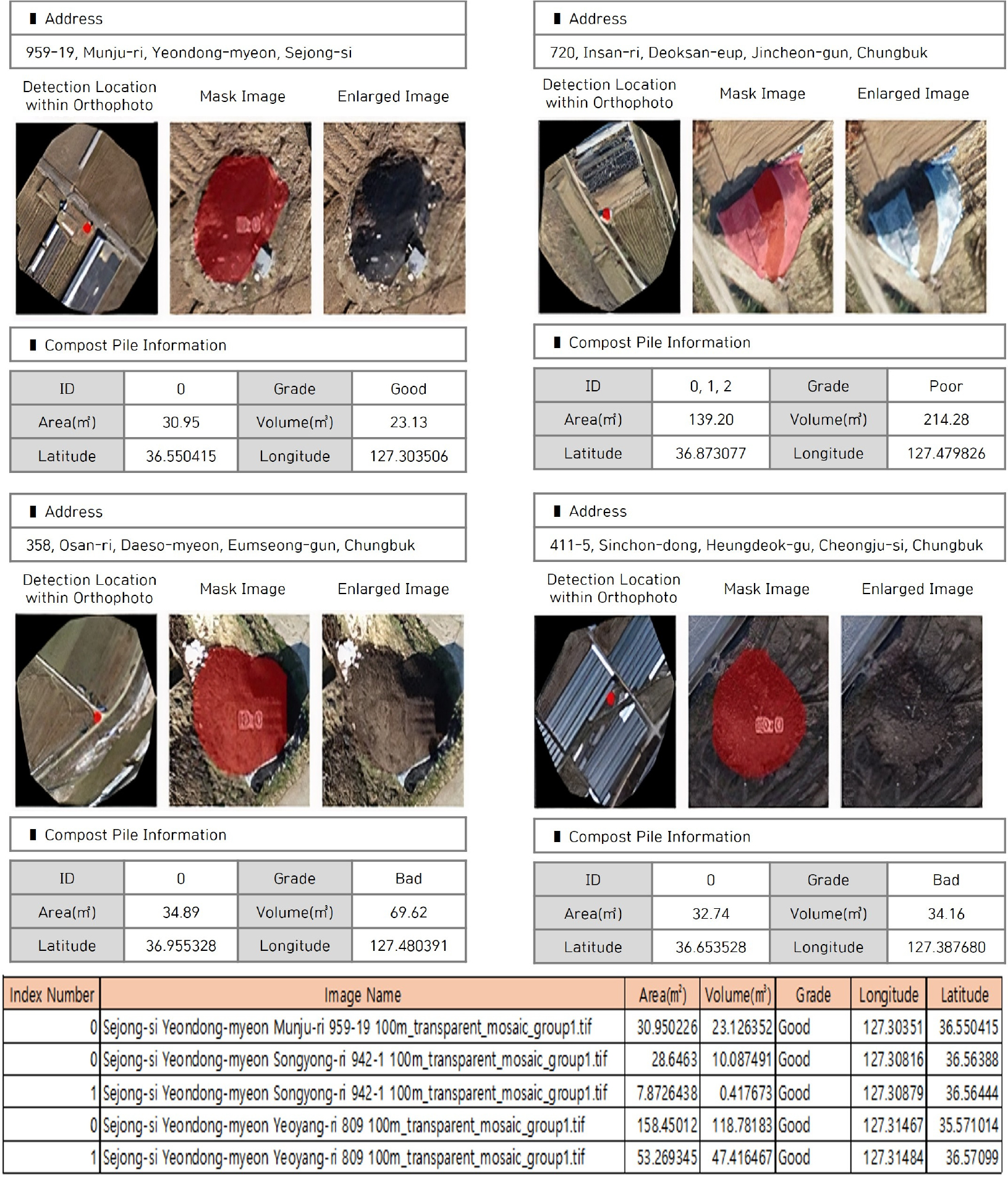
- This study quantitatively analyzed the spatiotemporal distribution and management status of compost heaps in the Miho River mid-watershed using UAV imagery and YOLOv8-based instance segmentation. Eight seasonal surveys conducted from June 2023 to March 2025 revealed a general increasing trend in compost heap occurrences, with significant seasonal peaks observed around March, aligning with spring cultivation preparations. The segmentation model achieved an Accuracy of 0.931 and an mIoU of 0.808. Specifically, Accuracy represents the precision of object classification, whereas mIoU (mean Intersection over Union) quantifies the spatial overlap between predicted masks and actual boundaries, validating the model’s high performance in accurately delineating heap areas. Management analysis highlighted March 2025 as a compounded risk period, characterized by maximum total volumes and the highest proportion of uncovered, "inadequate" heaps. Administratively, Heungdeok-gu in Cheongju and Dongnam-gu in Cheonan were identified as priority management hotspots due to their extensive farmland and concentrated livestock facilities. This research establishes an efficient UAV-AI monitoring framework for watershed-scale non-point source pollution and provides critical foundational data to support the development of effective environmental management policies.
- COLLAPSE
본 연구는 미호강 중권역을 대상으로 드론 영상과 딥러닝 기반 인스턴스 세그멘테이션 기법을 적용하여 야적퇴비의 시공간적 분포 특성과 관리 상태를 정량적으로 분석하였다. 2023년 6월부터 2025년 3월까지 3개월 간격으로 총 8회 계절별 조사를 수행한 결과, 야적퇴비는 전반적으로 증가 추세를 보였으며, 경작 준비 시기인 3월을 전후하여 개소수와 체적량이 증가하는 계절적 경향이 나타났다. 다만 증가의 폭과 양상은 하천별로 차이를 보였으며, 봄철 경작 준비 과정에서 퇴비가 집중 적재되는 농업 활동 특성과 밀접한 관련이 있는 것으로 해석된다. 야적퇴비 탐지에 활용된 YOLOv8 인스턴스 세그멘테이션 모델은 영남·호남 지역 학습 데이터를 기반으로 구축되었으며, 해당 데이터에 대한 검증 결과 객체 단위 분류 정확도인 Accuracy 0.931, 예측 마스크와 실제 마스크 간 겹침 비율의 클래스별 평균인 mIoU 0.808을 나타내어 유역 단위 야적퇴비 자동 탐지 및 모니터링에 활용이 가능하다고 판단하였다. 관리 상태 분석 결과, 특히 2025년 3월에는 총 체적량과 덮개 미설치 '부적절' 등급 비율이 동시에 최고치를 기록하여 비점오염원 유출 위험이 복합적으로 증가하는 시기임이 확인되었다. 행정구역별 누적 발생량 분석 결과, 충청북도 청주시 흥덕구와 충청남도 천안시 동남구가 농경지 면적과 축사 밀집도가 높아 우선 관리가 필요한 주요 지역으로 도출되었다. 본 연구는 드론 영상과 딥러닝 기법을 활용하여 유역 단위 비점오염원을 효율적으로 감시할 수 있는 체계를 제시하였으며, 향후 비점오염 관리 정책 수립을 위한 기초자료로 활용될 수 있을 것으로 기대된다.
-
Drone imagery and artificial intelligence-based investigation and management of pollution source distribution in the Miho River mid-watershed
-
Special Issue: 환경기초조사
-
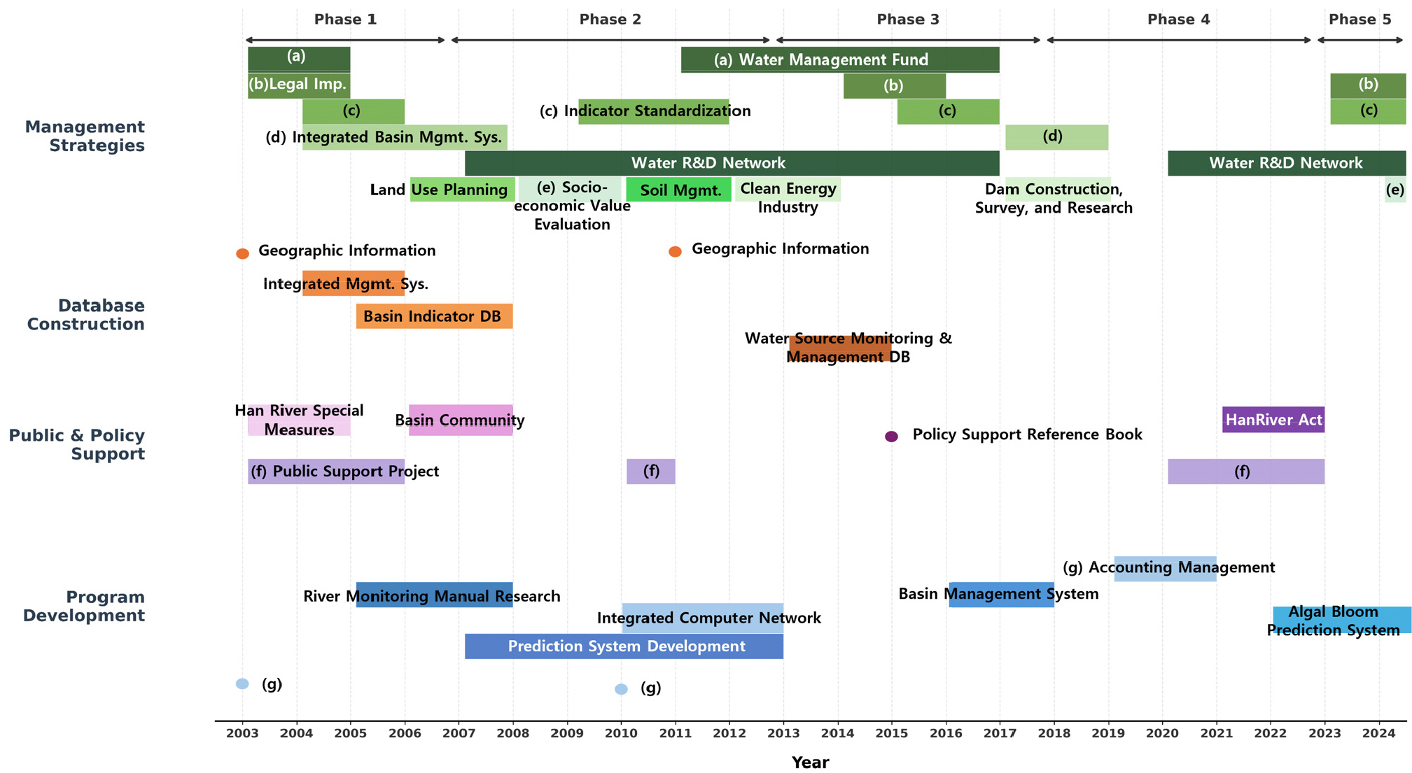
A time-series analysis of water management-related research trends in the Hangang River Basin Basic Environmental Survey Project, 2003–2025
한강수계 환기조사업의 시계열 분석을 통한 2003-2025년 연구동향 고찰
-
Lee, SeonahㆍSong, YejinㆍJung, SeyoonㆍAn, YongbinㆍHong, Eunmi
이선아, 송예진, 정세윤, 안용빈, 홍은미
- This study analyzed the distribution of research types and their temporal evolution in 84 reports related to the water management system within …
본 연구는 2003년부터 2025년까지 수행된 한강수계 환경기초조사사업 환기조 보고서 중 물관리체계와 직접 관련된 84건을 대상으로, 연구 유형의 분포와 시기별 전개 양상을 분석하였다. …
- This study analyzed the distribution of research types and their temporal evolution in 84 reports related to the water management system within the Hangang River Basin Basic Environmental Survey Project from 2003 to 2025. The analysis combined quantitative time-series assessment by publication year with qualitative review of full reports, and classified the studies into four categories: management strategy, database construction, public participation and policy support, and program development. Results showed that management strategy accounted for the largest share. Early research focused on institutional foundations and database construction, then expanded toward integrated management systems and management indicators, and more recently toward governance-based and prediction-oriented management. However, persistent limitations were identified, including weak linkage to practical implementation, reliance on data accumulation and conventional prediction, and fragmentation among water quantity, water quality, and aquatic ecology studies. These findings suggest that future projects should strengthen the linkage among investigation, analysis, and policy support, while advancing intelligent management systems and integrated watershed interpretation frameworks.
- COLLAPSE
본 연구는 2003년부터 2025년까지 수행된 한강수계 환경기초조사사업 환기조 보고서 중 물관리체계와 직접 관련된 84건을 대상으로, 연구 유형의 분포와 시기별 전개 양상을 분석하였다. 분석은 발간 연도 기준의 시계열 정량 분석과 보고서 전문 검토에 기반한 정성 분석을 병행하였으며, 연구 목적과 핵심 산출물을 기준으로 관리 전략, 데이터베이스 구축, 주민 참여 및 정책 지원, 프로그램 개발의 4개 범주로 분류하였다. 분석 결과, 관리 전략 유형이 가장 높은 비중을 차지하였고, 초기에는 제도적 기반 마련과 데이터베이스 구축이 중심이었으나, 이후 통합관리시스템 고도화와 관리지표 개발로 확장되었으며, 최근에는 거버넌스 기반 현안 대응과 예측 중심 연구가 증가하는 경향을 보였다. 한편 실무 연계성 부족, 자료 축적·전통적 예측 중심의 한계, 단일 매체 중심 연구의 분절성도 확인되었다. 따라서 향후 환기조사업은 조사–분석–정책지원의 연계 강화, 지능형 관리체계 도입, 통합 유역해석 프레임워크 확장을 통해 보다 실효적인 물관리 지원체계로 고도화될 필요가 있다.
-
A time-series analysis of water management-related research trends in the Hangang River Basin Basic Environmental Survey Project, 2003–2025

Journal Informaiton
 Journal of Korea Water Resources Association
Journal of Korea Water Resources Association


한국수자원학회
#302 Han-Shin Living Tower, 237 Hyoryeong-ro, Seocho-gu, Seoul 06671, Korea
Tel: +82-2-561-2732 / Fax: +82-2-561-2733 / E-mail: kwra@kwra.or.kr Copyright© KOREA WATER RESOURECES ASSOCIATION. Powered by APUB
Tel: +82-2-561-2732 / Fax: +82-2-561-2733 / E-mail: kwra@kwra.or.kr Copyright© KOREA WATER RESOURECES ASSOCIATION. Powered by APUB

창간호부터 2015년도까지의 자료는 Archives 에서 확인하실 수 있습니다.

CLOSE

창간호부터 2015년도까지의 자료는 Archives 에서 확인하실 수 있습니다.
CLOSE